CLEVELAND — 2020: A very snowy Christmas Day.

Below are time-stamped updates of how the winter storm is impacting Northeast Ohio. Be sure to refresh this page frequently for the latest updates, which will appear at the top of the blog below.
LIVE RADAR: Track the snow in your area
DEC. 26
10:28 p.m. The winter storm warnings and advisories have expired for all of Northeast Ohio. However, the cleanup continues.
DEC. 25
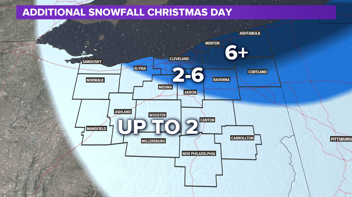
3:30 p.m. Lake snow bands are shifting northward as the wind backs around to a more southwesterly direction. This will mean east to west orientation of the snowbands. Eastern Cuyahoga, Lake, northern Geauga and Ashtabula county will continue to see lake snow overnight and into early Saturday. As usual, additional accumulations depends upon where bands persist, but another 3" to possibly as much as 8" will be possible, with the highest additional amounts farther east. Winter storm warnings continue for the primary snowbelt until 7 a.m. All other alerts have expired. (BK)
3:10 p.m. Meteorologist Matt Standridge has an update on weather conditions, watch his mini report in the player below.
11:30 a.m. ODOT says it has more than 800 crews on the road statewide. They are asking that driver giver their employees "plenty room" to successfully to their jobs.
10:24 a.m. The City of Lorain has issued a parking ban effective immediate and will remain in effect until further notice.
9:40 a.m. ODOT shared driving tips for those hitting the roads today.10:
9:30 a.m. The city of Warrensville Heights has also issued a parking ban. The ban will remain in effect until Saturday, December 26 at 6 p.m. Parking of vehicles upon any and all city streets are prohibited, and any vehicle parking in violation shall be towed and charged in accordance.
9:24 a.m. The City of Cleveland has issued a parking ban. The ban will remain in effect until Saturday at 8 a.m.
8:20 a.m. A before and after look at downtown Cleveland following roughly eight inches of snowfall in 16 hours.
8:13 a.m. Winter Storm Warning remain in effort for much of the 3News viewing area.
8:10 a.m. The City of Parma has placed a Snow Emergency Parking Ban in effect until further notice. There is no parking on any streets within the city.
7:50 a.m. ODOT says it has more than 800 crews working on roads across the state. They're asking for people to stay home if possible.
7:15 a.m. Meteorologist Matt Standridge has a look at the seven to eight inches that fell in downtown Cleveland overnight.
6:40 a.m. Lindsay Buckingham gives us a look at her very White Christmas this morning.
DEC. 24
11:40 p.m. The National Weather Service has issued a Winter Storm Warning for Lorain and Medina counties, in addition to Cuyahoga, Lake, Geauga, Ashtabula, Summit, Stark, Portage, and Trumbull counties.
11:23 p.m. Mark Naymik checked in with ODOT to see how the crews are progressing as the roads continue to be treacherous throughout Northeast Ohio.
11:12 p.m. Here's an update on how the winter storm is progressing with Meteorologist Matt Wintz:
9:56 p.m. Photojournalist Kelly Matter checks in with some images of the snow at Crocker Park in Westlake:
9:35 p.m. Let's check in with the good people from ODOT for a look at how crews are making out tonight in Akron and areas east and south of Cleveland.
8:50 p.m. Here's how things look out on the roadways in and around downtown Cleveland with photojournalist Sean Forester. As he says, if you don't have to be out there tonight, please stay home.
8:11 p.m. Meteorologist Matt Standridge shot some video of the conditions in downtown Cleveland.
8:00 p.m. Meteorologist Matt Wintz is giving us a detailed look at the snow making our way across the area now on Facebook Live
6:58 p.m. According to Meteorologist Matt Wintz, look for the next wave of snow to start moving in. The heaviest may occur between now and 1-2 a.m.
6:45 p.m. The National Weather Service has issued a Winter Weather Advisory for Ashland and Richland counties, along with Knox County.
5:31 p.m. Here's the latest weather update from 3News Meteorologist Matt Wintz:
Also, photojournalist Sean Forester shared this video of conditions on the west side:
5:17 p.m. Here's the latest from ODOT as plow crews work to keep the roads safe. There are reports of accidents around Northeast Ohio, so please take it slow and be careful if you have to be out.
3:57 p.m. Visibility will be a huge concern when you are driving.
3:15 p.m. Roads are starting to get slick
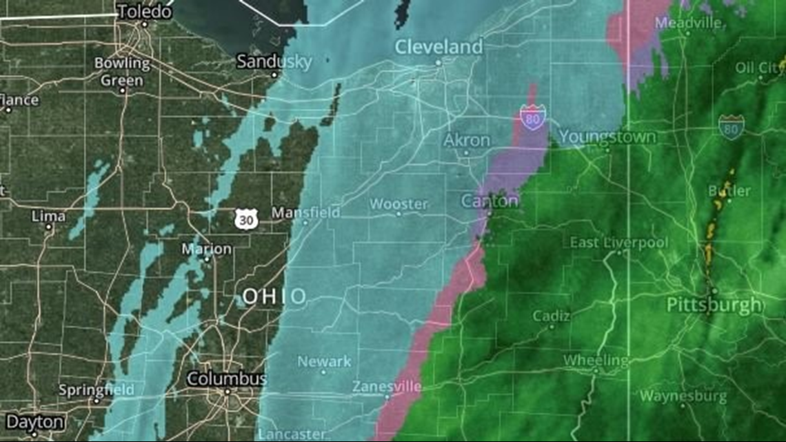
2:42 p.m. Check out the snow on radar:

2:33 p.m. The snow is starting to accumulate in the downtown area.
2:11 p.m. Snow has arrived in Cleveland.
2 p.m. A parking ban has been announced for Warrensville Heights. It will be in effect from 6 p.m. Dec. 24 until 6 p.m. Dec. 26. "Parking of vehicles upon any and all city streets are prohibited, and any vehicle parking in violation shall be towed and charged in accordance," city officials said in a press release.
1:22 p.m. We'll just leave this here...
1:16 p.m. If you don't have to travel tonight, you can always hunker down and watch Santa Claus on his journey around the world with the NORAD Santa tracker.
1:01 p.m. A look at the current temperatures:
12:55 p.m. 3News' Matt Standridge offers an updated look at the radar:
12:51 p.m. 3News' Matt Wintz offers an updated look at potential snow totals:
12:45 p.m. Here are the most recent weather alerts from the National Weather Service...
WINTER STORM WARNING
In effect from 1 p.m. Thursday, Dec. 24 until 7 a.m. Saturday, Dec. 26:
- Ashtabula
- Cuyahoga
- Geauga
- Lake
In effect from 1 p.m. Thursday, Dec. 24 until 1 p.m. Friday, Dec. 25:
- Mahoning
- Portage
- Stark
- Summit
- Trumbull
In effect from 4 p.m. Thursday, Dec. 24 until 1 p.m. Friday, Dec. 25:
- Carroll
- Columbiana
- Tuscarawas
WINTER WEATHER ADVISORY
In effect from 1 p.m. Thursday, Dec. 24 until 7 a.m. Friday, Dec. 25:
- Holmes
- Lorain
- Medina
- Wayne
12:02 p.m. A look at how the storm is expected to impact the area:
11:32 a.m. The snowflakes haven't even started flying yet, but ODOT said their crews are already out treating roadways across the state:
10:18 a.m. ODOT said they are prepared for the incoming winter storm with more than 250 plow drivers ready to dispatch. Crews will work around the clock in 12-hour shifts:
MORE HEADLINES: