ATLANTA - The Latest on severe weather in the South (all times local):
5:45 p.m.
The New Orleans area has seen significant street flooding throughout the day, fed by quick bursts of rain in a short time, followed by steady showers.
Water was knee-high on some city streets Friday and even higher in others.
National Weather Service meteorologist Christopher Bannan says nearly 5 inches of rain fell at the lakefront airport, while just under 4 inches of rain was recorded at New Orleans' international airport.
Bannan says a heavy line of storms currently moving through the area should be cleared out by late evening.
___
3 p.m.
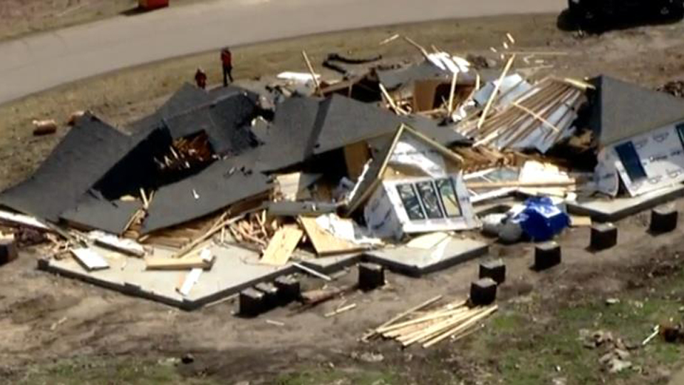
The National Weather Service confirms a tornado touched down in a central Georgia community and did some damage.
Meteorologist Steve Nelson says a tornado plowed through Twiggs County with 90 mph winds near Allentown, Georgia, around 8:40 a.m. Friday. Nelson says it traveled 1.9 miles, damaging eight homes and destroying two.
He says it's possible that another tornado later in the morning hit neighboring Wilkinson County, causing some damage to homes and trees.
Wilkinson County Emergency Management director Gary Brown says three homes were damaged in the corner part of the county. He says one home was completely destroyed and the other two had minor damage.
In nearby Warner Robins, some streets were flooded and roofs damaged at Robins Air Force Base, and the airfield at Robins was temporarily closed. There were no immediate reports of injuries.
___
11:35 a.m.
Some streets were flooded and roofs damaged at Robins Air Force Base and the surrounding community in central Georgia when severe storms pounded the area.
A base spokesman said Friday that the airfield at Robins has been temporarily closed.
Base spokesman Vance "Geoff" Janes said in an email that the roofs of several buildings were damaged and power lines were downed by straight-line winds that reached 72 knots. More than an inch of rain fell on the base, flooding some streets and parking lots.
In surrounding Houston County, Emergency Management Director Jimmy Williams said there was "significant damage" in Warner Robins.
Williams said that trees fell into homes and power lines in an area that measures about 2½ miles by 6 miles. He said preliminary estimates indicate that about a dozen homes suffered significant damage, while others had minor damage.
He said about 35,000 homes and businesses were without power.
No injuries were reported.
___
10:15 a.m.
High winds along the Mississippi Gulf Coast have snapped power poles and downed trees.
Forecaster Angel Montanez at the National Weather Service office in Slidell, Louisiana, says it happened Friday morning near the intersection of Interstates 10 and 110 in Harrison County.
Montanez says similar damage was reported in Jackson County east of D'Iberville.
He says radar reports did not show any circulation in the storms that moved through the area.
___
9:35 a.m.
A utility company was working to restore power after a strong storm produced wind gusts of more than 80 mph and left thousands of customers without electricity in central Georgia.
Flint Energies reports that more than 6,000 of its customers were without power shortly before 9 a.m. Friday after a storm and tornado warnings in and around Houston County, Georgia, south of Macon.
Earlier, the National Weather Service had issued tornado warnings in the area for parts of Houston, Peach, Crawford, Twiggs and Taylor counties.
The weather service reported that a weather station in the Warner Robins area recorded a peak wind gust of nearly 83 mph as the storms moved through the area.
Crawford County Emergency Management Agency Director Rick Sharon told The Telegraph newspaper that there were numerous trees down and some flooding in his county.
___
8:15 a.m.
The line of storms that brought tornados to three Southern states is moving into the Carolinas, bringing the threat of severe weather.
The National Weather Service issued a tornado watch for a dozen counties in central and southern South Carolina early Friday.
The weather service says tornados and isolated high winds are possible until 3 p.m. Friday.
The first watch-affected area stretches from Aiken County east and south but doesn't include the state's beaches.
The storm system was expected to move generally northeast through North and South Carolina on Friday.
Duke Energy reported about 1,500 customers without service early Friday, most in North Carolina. South Carolina Electric & Gas reported about 1,200 without service. Most were in Saluda and Lexington counties.
___
8:15 a.m.
The National Weather Service says a slow moving cold front is the focus for heavy rain across southeast Louisiana and the Mississippi Gulf Coast.
High rain rates could produce rapid ponding on roadways and flash flood conditions in some locations Friday night.
Forecasters in Slidell, Louisiana, expect 1 to 3 inches with some higher amounts possible.
There is a slight risk of severe thunderstorms with strong wind gust and isolated tornadoes.
___
8:15 a.m.
The National Weather Service in Jackson, Mississippi, will send out three storm survey teams to assess the damage from storms to determine whether tornadoes were responsible.
The teams head out Friday. One will head to Dermott in Chicot County, Arkansas, to assess the damage from a Wednesday storm.
In Mississippi, another team will survey Lowndes County around New Hope from a storm on Thursday that damaged one home and downed trees and powerlines.
A third team will survey similar damage in Lamar County around Purvis from a storm that occurred Thursday morning.
___
7:50 a.m.
Many of the severe storms that rolled through southern states overnight have diminished, but flood watches remained in parts of Alabama, Georgia and the Florida panhandle early Friday.
The National Storm Prediction Center says a large part of Georgia and the Carolinas will be at a slight risk of more storms later Friday. Forecasters say damaging wind gusts and the potential for a few tornadoes will be the main threats.
Parts of three Georgia counties were under a tornado warning early Friday. The National Weather Service said a severe storm capable of producing a tornado was being tracked on radar south of Macon. There were no immediate reports of any tornadoes on the ground or damage from that storm.
Earlier, tornadoes swirled through Louisiana, Mississippi and Alabama on Thursday as storms headed east.
___
4:55 a.m.
Tornadoes swirled through Louisiana, Mississippi and Alabama as the severe storms head toward the Carolinas.
Emergency management officials Rita White and Harry Markham say one tornado touched down in Eldridge in central Alabama around 8 p.m. Thursday and another hit about hour before in Ardmore in the northern part of the state. There were no immediate reports of damage or any injuries.
The National Weather Service confirmed two tornadoes touched down in southeastern Louisiana, bringing down trees and power lines but causing no injuries.
An apparent tornado also damaged homes and downed trees near Columbus, Mississippi.
Lowndes County Emergency Management director Cindy Lawrence says reports indicated at least a dozen homes were damaged near New Hope, between Columbus and the Alabama state line.
---
Follow the Channel 3 Weather Team on Twitter @wkycweather and on Facebook


